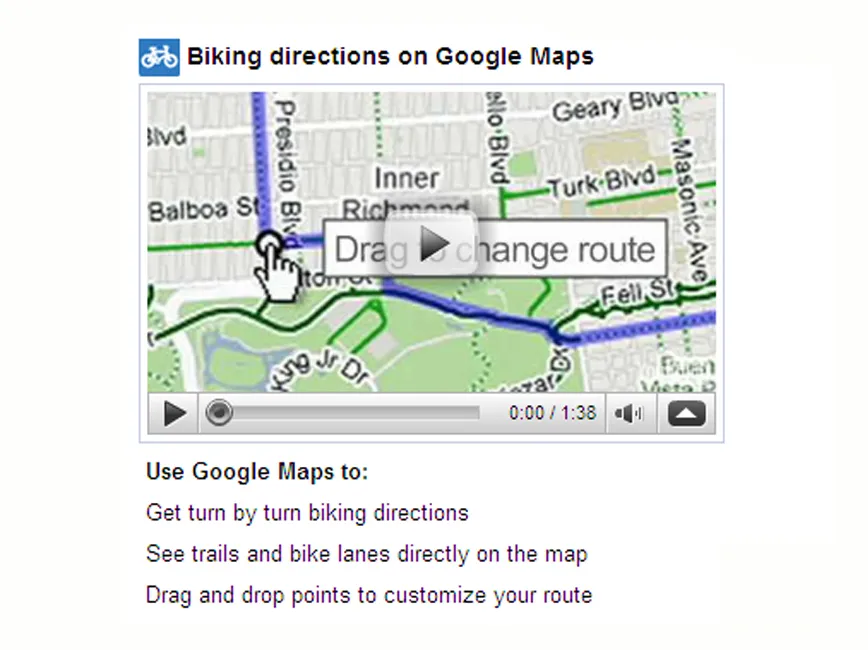
Google Maps are offering a new 'bicycling directions' function to users in 150 US cities. It’s a project that fits in well with the US-based company, who boast an avid cycling community within their employee base.
Hours after the 'bicycling directions' launch at the National Bicycle Summit in Washington DC, BikeRadar caught up with Google Maps spokeswoman Elaine Filadelfo to get the lowdown.
BikeRadar: Will the 'bicycling directions' function be available in the UK and Europe?
Elaine Filadelfo: We don’t really have a timeline to announce that, unfortunately. We know people are very eager and there is a demand for this all over the world, but we don’t have anything specific right now. We’re looking into the various ways to make it possible, but there are some difficulties concerning some of our data sets in other countries that make it a little bit trickier than in the US.
[In the US, Google’s base map is based on a wide range of publicly available data sources, which aren’t as readily available in other parts of the world. Google also use a different process, including third party providers, to create data sets in other countries Ed]
Can you tell us when the bike mapping function will expand to more US cities?
Just to clarify, we have 150 cities – that refers to where we have detailed information about bike trails, bike lanes and preferred routes for cycling – but anywhere in the country you can still get the step-by-step, turn-by-turn directions. It’s just that in areas that aren’t part of those 150 cities it will use roads, but it will optimise the roads it chooses to be more bike friendly. So anyone in the country can get bike directions, its just in the 150 cities where they’ll be able to take advantage of bike trails and bike lanes whenever possible.
To expand we certainly hope to keep adding new areas and bringing new trails into existing areas. The other thing will be to keep up with the new growth of bike lanes and things like that. One of the ways we hope to do this is by getting feedback from users, because they’re the ones riding in their hometowns every day and know the best routes or when things change. There’s a button at the bottom of the map to report a problem that will take any feedback, suggestions or comments that we really are encouraging people to make use of and let us know.
How does the function optimise a route, especially in cities that don’t have detailed bike path and trail information?
It’s a pretty complex algorithm that looks at all of the variables [including hills, traffic, road type and many others] and tries to come up with the most efficient final route. For example, it will prioritise putting you on a trail or a road with a bike lane and weigh that against how far out of your way it might send you or how hilly that terrain might be. We look at all of the variables in conjunction, but I would say the strongest factor we look for is to put you on a bike trail.
How long has the function been in development?
There are two answers to that. We have been thinking about it for two years, while doing some work here and there on it, but the base map data that’s key to making this possible only became available in October of last year. Since that launched there’s been a team of five engineers in our Seattle office who have been working full-time on making this happen, so that’s about five months or so.
We’ve seen pictures of a bike outfitted with an elaborate camera; how did that fit into the project?
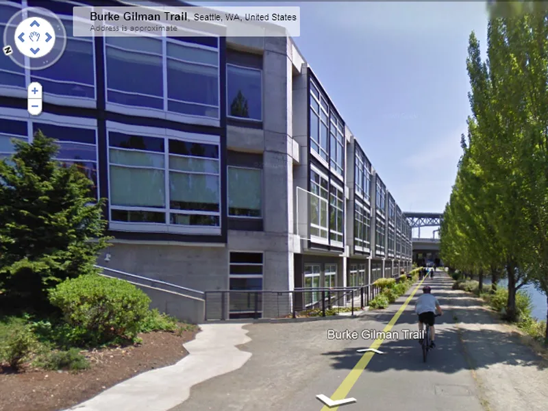
The tricycle is a three-wheeled bicycle system that has our Street View cameras on it and goes to all sorts of pedestrian-only non-motorised areas. We have Boston University, for example, and it allows you to do a tour of that campus, or Sea World in San Diego – you can take a virtual tour there as well. It has also done biking trails. We only have a couple now, but we’re working on adding more, especially since we have this feature. The ones we have now are of the Monterey Coastal path and the Burke-Gilman trail in Seattle, which is where the Google Maps team is based and you can actually see their office right along the trail.
Tell us about the petition to get the ‘bike there’ function on Google Maps...
It’s called googlemapsbikethere.org, and was started by a really active cyclist based down in Austin, Texas. When we checked right before we launched it had 51,000 signatures, so we certainly saw that. We actually started working on the project a little bit before then, but seeing that support made us realise that, yes, we are on the right track and that this is something really good for our user community.
Did Google partner with any bike organisations for this project?
We partnered with the Rails-to-Trails Conservancy. They were one of our main partners and gave us more than 12,000 miles of trails all around the country. We announced at the National Bike Summit held by the League of American Bicyclists today. They’ve been really supportive of this.
Can people add the function to their own websites?
Yes. API (Application Programming Interface) is the ability to embed the map on your own website and then you can do some customisation by putting your own data over it or some more complicated things. This means any cycling organisation or bike shop can put either the API or a gadget on their website that will help people get riding directions to their destination. The gadget is meant to be a lot simpler and mainly for directions to a destination. The API will give you a map and is made for a more sophisticated user.
What’s the next step for Google's 'bicycling directions'?
The next step is to make this available on mobile phones. We were hoping to launch that at the same time, but we knew that this was ready in time for the convention and really wanted to be able to announce it today. Mobile will be coming pretty soon and we think it will be a really great experience. After that, we’ll just be working on the quality and the amount of data that we have. One of the other things we’ll be doing in the US at some point in the not-too-distant future will be opening up our tool called Map Maker, which is available in some other countries around the world, that allows people to contribute data directly onto Google Maps instead of filling out the form that’s available now.
In terms of size, where does the five-person team that worked on this project fit, and what sort of scale was this project for Google?
Size really does vary. They’re part of the larger Google Maps team and our whole Geo team, specifically our Directions team, and they’re not 100 percent full-time on bike directions eight hours a day. They work on all of the things in Google Maps that have to do with directions, whether it’s the algorithm to get you there or how the map looks when you turn on traffic. It’s a smaller team and they work on several projects. It really can vary, because so many things are of such different magnitude – something like Gmail [is enormous] versus adding to our public transit layer.