Routes
London's Barclays Cycle Superhighway 8 imminent
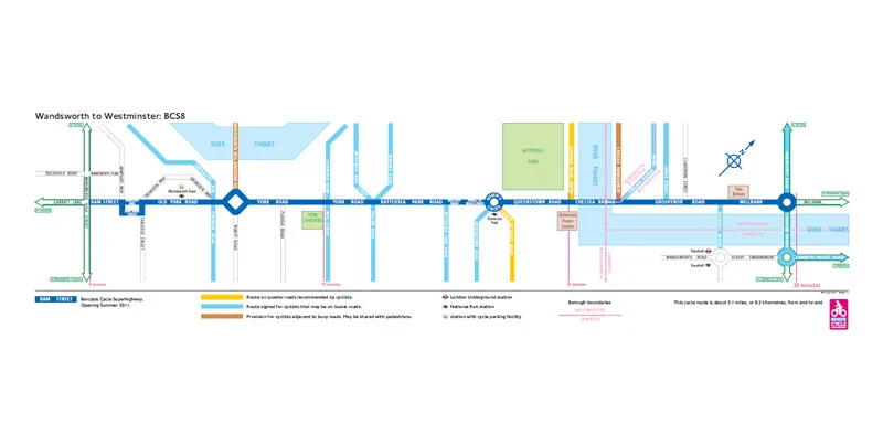
With two of London's Barclays Cycle Superhighways now completed, the next one – No. 8, which connects Wandsworth with Westminster – is due to be opened on 19 July. Transport for London, the overseers of the project, say that cycle journeys on the first two Superhighways are up between 50 and 100 percent compared to when they were on normal roads in 2009.
Jubilee & Olympics route in the offing
A circular 37-mile route round central London is planned for the Queen’s Diamond Jubilee in 2012 that will also, handily, join many of the Olympic sites. It'll link Hyde Park in the west to Excel in the east and use paths alongside or through Regents Canal, Victoria Park and the Thames. Waymarking will be done via what are described as ‘distinctive glass pavement slabs’, though detailed maps of the route can already be found at www.jubileegreenway.org.
Great Stour Way opens
This three-mile traffic-free trail links the south-west edge of Canterbury with Chartham via the River Stour. It offers easy access to the Kent Downs and completes the 45-mile Pilgrims Cycle Trail between Canterbury and Rochester cathedrals.
Drakes Trail
Work is continuing on this trail between Tavistock and Plymouth. While it's already rideable as part of the Devon Coast to Coast route, a tunnel reopening at Grenofen and a new £2 million, 1,000ft long bridge over the Walkman Valley will help avoid difficult roads and tracks and make it much more family and beginner friendly. Works are underway at both sites, though it’s likely to be 2012 before both are fully open. Keep up to date at www.drakestrail.co.uk.
More of Moors to Sea
New sections of the Moor to Sea Cycle Route have been added to the signed network of loops that covers the North Yorkshire Moors (the area bounded, roughly, by Scarborough, Whitby and Pickering). The network now covers about 150 miles (originally it was around 80 miles).
Numerous shorter circuits are possible, and around half of the route is off-road on usually decent quality forest tracks and bridleways. The longest new link is out to Great Ayton via Rosedale Abbey. Details of the new additions can be found at www.moortoseacycle.net.
‘Classic’ Sustrans greenway gets green light
A new traffic-free route between Bilton, Harrogate and the village of Ripley has been given the official go-ahead. The four-mile route – largely rail corridor – will use the impressive Nidd viaduct and open up the Yorkshire Dales to cyclists coming from Harrogate. Sustrans say work will start this summer, with expected completion in spring 2012, and that the route has the makings of a ‘classic’.
Great North Cycleway
This 70-mile route from Blyth in Northumberland to Darlington was launched recently – though it will take some years before it's fully complete. Some sections – such as that through Newcastle city centre – are already decided, but in other areas such as Gosforth the route still needs to be consulted on.
New cross-Wales route starts its long journey
Towpath improvements on the spectacular Llangollen Canal (linking the town to the world renowned Pontcysyllte aqueduct) are now complete. This is just a tiny section of what will be National Cycle Network Route 85, linking Wrexham and other border communities to the Welsh coast at Barmouth. Sustrans say they're working to identify a number of traffic-free sections that can be linked via quiet roads to form a route across the heart of north Wales.
Your neck of the woods
Sustrans have countless local projects going on across the country. Vital route links that may have stopped people accessing places by bike are opening up all the time. Go to www.sustrans.org.uk/connect2 to discover what’s happening in your area.
New books
The Good Mountain Biking Guide (£19.95, ISBN 9780956802903)
The Good Mountain Biking Guide is a solid attempt to pull together the best trails from around the country using the vast public rights of way network. It also identifies the main trail centres. While it only covers England and Wales, it’s still quite a tome at some 637 pages.
It’s packed with bespoke maps identifying the trails at varying scales, usually around 1:75,000. Farm track type trails are identified as opposed to other (likely trickier or rougher) trails, which is extremely handy, though it would have been nice to get more than just the occasional comment on the exact condition of the surface and surroundings. Pubs, cafes and parking are also there. The index of 3,000 place names is handy too.
All the usual contenders for mountain biking areas are there, including the Peaks and the Lakes, but there are also many exciting sounding areas you might not have thought of exploring: the Isle of Man, Cheviots, Shropshire Hills or the Quantocks anyone? Highly recommended. The Good Mountain Biking Guide is available from Cordee
Moors to Sea (£3.50)
Eleven route leaflets detailing the route network as described above. Available from the North York Moors National Park online or at local information centres.
Britain’s Great Waterways Outdoors (£19.95, ISBN 9780956069931)
The idea is great – identify the best waterways across the country for walking, cycling and boating in one book. Each regional chapter starts with a little summary of all the canals in the area followed by a summary of Sustrans type cycle routes along the waterways. There's then a small section of detailed route suggestions for cyclists, walkers and boaters, and pages on wildlife, days out, food and drink.
It’s a great coffee table book packed with good suggestions for cyclists who love the calmness that often accompanies waterside rides. It would be great to see more cycle route suggestions and detailed more useable maps if a second edition comes out. Available via Sustrans.
Pocket Mountains Guides to Welsh NCN Routes: Lon Cambria & Lon Teifi (£6.99, ISBN9781907025228) and Lon Las Cymru (£7.99, ISBN9781907025211)
As the name hints, these guides fit in your pocket and are a handy accompaniment to the National Cycletwork route maps. Lon Las Cymru heads north to south across Wales for some 400km while Lon Cambria and Lon Teifi link the west coast (Fishguard or Aberystwyth) to Shrewsbury with 340km of route.
The guides give handy route summary sections, basic overview maps, what to see and suggestions for where to stay (though it would be nice to see more detail in these last two sections – not least phone numbers for accommodation listed). Bilingual in English and Welsh. Available via Sustrans.